
In 2019, Barnsley Museums and Archives staff set out on a creative project to discover more about an intriguing set of photographs of Hoyland taken in the 1950s. Each image features a man with a painted arrow and a sign board. Who is he? What is he pointing at, and why? Tegwen Roberts, Elsecar Heritage Action Zone officer, and David Blunden, Local Studies Librarian at Barnsley Archives, tell us more.
An intriguing set of photgraphs
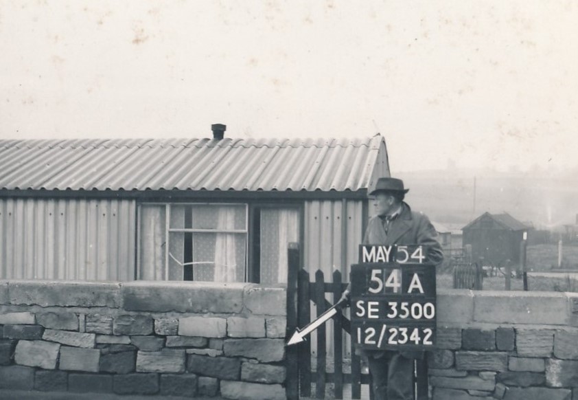
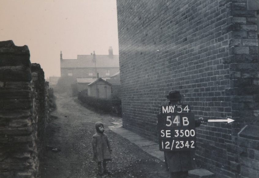
Barnsley Archives has thousands of amazing historical photographs of Barnsley, but one set of images taken in the mid-1950s is particularly curious. Each photograph includes a man with a painted arrow and a sign board, pointing at seemingly random objects, including walls, pylons and telegraph poles. Who is the man, and what is he doing? These are questions that we started to ask in 2019, when the photographs were digitised by archives staff and became available to the public for the first time.
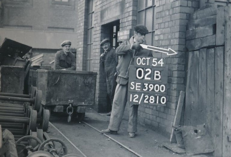
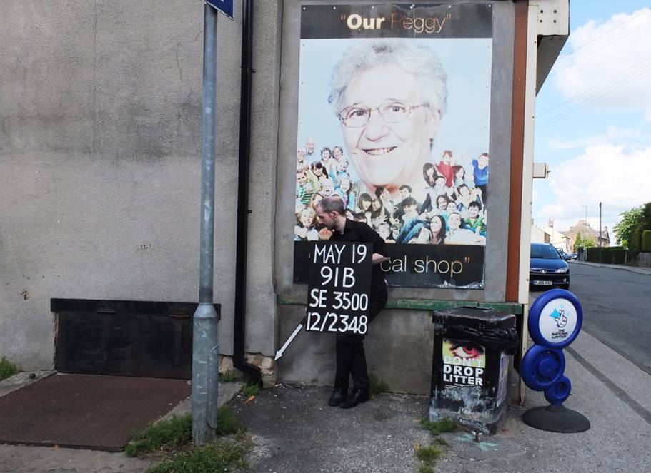
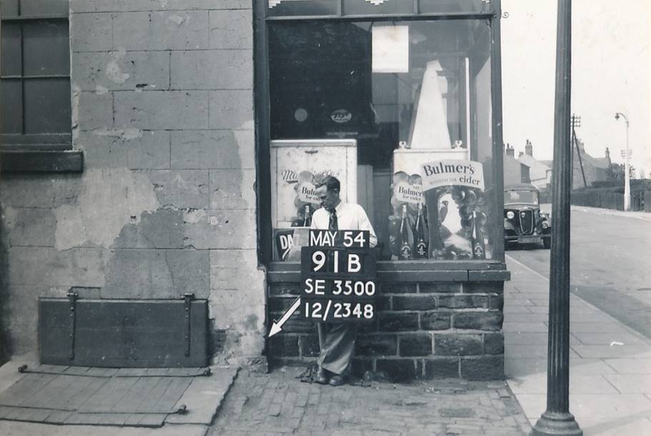
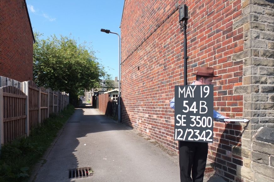
We did some more research and discovered that the photographs were taken by the Ordnance Survey as part of a post-war mapping project. The man in the photos is an Ordnance Survey surveyor, and he’s pointing to a series of Revision Points, shown as rp on the finished maps. These were fixed points in the landscape, used to ‘control’ the detail on the new 1:10000 and 1:125000 scale Ordnance Survey maps and make sure the maps were as accurate as possible. The sign board gives each point a unique number.
The point locations were recorded in survey books. In some areas, including Hoyland, photographs were also taken to make the points easier to find again when the maps were updated. The photographs were obviously used, as some of them have ‘destroyed’ written across them, presumably after the structure with the revision point on was demolished.
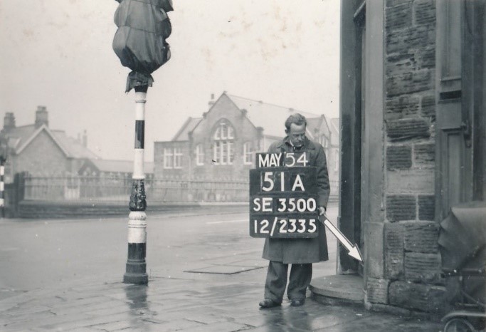
Although they were taken for a specific purpose, these images also provide a unique snapshot of everyday life in the 1950s. The surveyors often chose street corners for their points, as this gave them more than one line of sight. Where this wasn’t possible, they would use whatever fixed points they could find, including walls of houses, railway embankments, alleyways, footpaths, industrial buildings and field boundaries. In many of the shots it is the backgrounds that are most interesting.
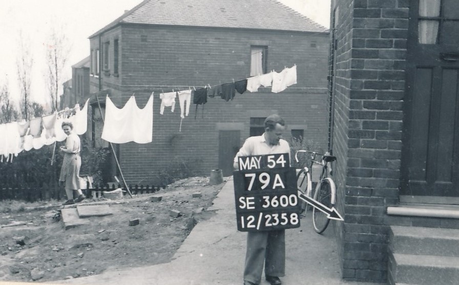
The Barnsley photographs, which cover Hoyland, Hoyland Common, Tankersley, Hemingfield and the outskirts of Elsecar, show the post-war housing estates, rows of prefab housing built after the war as temporary accommodation, and air raid shelters used as garden stores. They also include rare working shots of Elsecar Main Colliery and Rockingham Colliery.
Capturing a moment in time
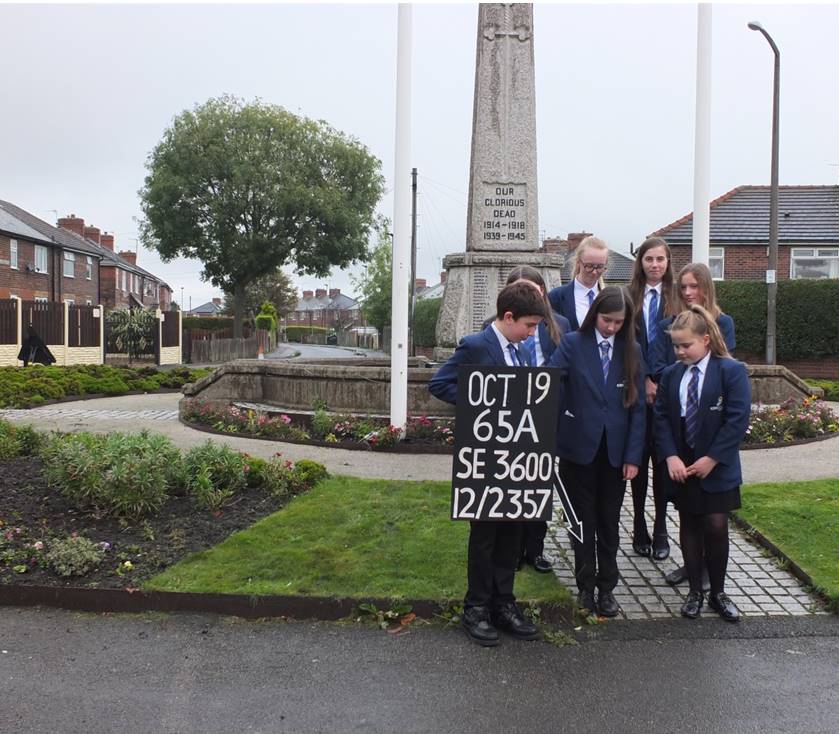
The Hoyland photographs were mainly taken in May and June 1954. As 2019 marked 65 years since they were taken, we decided that it would be interesting to recreate some of the images, during the same months they were originally taken, to see how things had changed. We made a sign board and arrows, borrowed a hat, and set off.
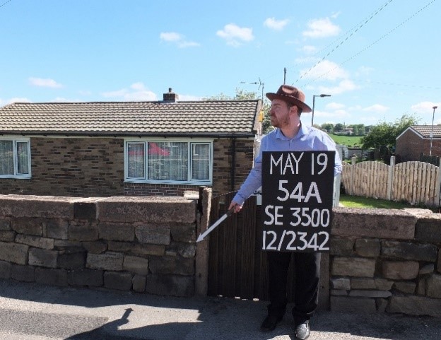
We put the first photographs on social media, and they raised a lot of interest, both locally and further afield. They were so popular that we decided to widen the project and create a temporary exhibition, as a joint project by the Elsecar Heritage Action Zone, Barnsley Archives and Hoyland Library, working with Barnsley Museums’ Digital Curator (modelling a fine trilby hat, above).
Taking the photos with the props proved to be a talking point in itself. Lots of local residents stopped to ask what we were doing, and when we explained and showed them the original photographs, many stayed to chat and share their memories. One lady in Hoyland Common told us about working in the beer-off on the corner of Stead Lane when she was a teenager. The barrels were kept in the cellar below, with the beer sold in jugs from two hand-pumps on the counter. She remembered swinging on the street light outside the shop as a younger child. She was also a champion runner and regularly competed at Rockingham Sports Ground.
You can see that the photographs also caused a lot of interest when they were originally taken, with people in the backgrounds of the photos stopping to look at the camera, or the man with the sign.
We invited local people to help us take the photographs, including the Friends of Hemingfield Colliery, who happily got involved. We also worked with the students at Kirk Balk Academy, which is featured in some of the images. We ran a workshop with the school history club, looking at the historic Ordnance Survey maps and matching the photographs to the ‘rp’ points, based on what was visible in the photographs. Then the students helped us to recreate a selection of their favourite images, including the war memorial close to the school.

With graphic design support from Ailsa Robinson, Events and Programmes Assistant with Barnsley Museums, the exhibition was created.
Picturing Hoyland Exhibition
The final exhibition went up at Hoyland Library in October 2019 and ran until December 2019. We included the arrows and signboard as part of the exhibition. Library staff encouraged visitors to engage with the exhibition, take photographs of themselves with the props, and share their stories and memories of the places in the photographs.
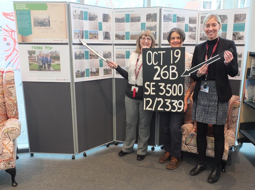
The exhibition was a great success, with older people bringing family to see photographs of places they remembered, and others discovering new things about places they see every day but had never looked closely at before. It proved so popular that we are hoping to bring it back at some point in the future.
Visit the exhibition and listen to the podcast
Although the exhibition has now finished, you can still explore a digital version on the Barnsley Museums flickr page (just click on the image below). Let us know if you or your family recognise any of the places in the photographs and have any stories about them that you’d like to share.

You can also listen to a podcast about the project, recorded with Tegwen, David and Sara from Hoyland Library.
Similar Revision Point photographs were taken in other parts of the country, including Croydon, Liverpool and Taunton. The largest surviving collection, from Manchester, has recently been digitised. Find out more on the Ordnance Survey website.

The Elsecar Heritage Action Zone is a three year partnership between Barnsley Museums and Historic England. Find out more about it on the Historic England website. For more information about Barnsley Archives please visit the Barnsley Museums website.

You must be logged in to post a comment.